Space currently provides critical mission access for military tactical communications and other activities, but has become a growing civilian element in social and economic life. The US Department of Homeland Security estimates that £1.6 trillion of US revenues in 2016 derived from space-related data. A substantial number of existing military satellites near the end of their operational lives, which required high development and operational costs, and long construction cycles.
Replacement of these satellites with smaller, more cost effective solutions, using a platform architecture that allows for exploitation of similar civilian markets is attractive. For example, a Global Positioning System (GPS) IIR satellite costs about US $500M to build and $300M to launch. Military planners are thus exploring a range of cheaper options for modern satellites, including technological upgrades, and new launch techniques. Nanosatellites (nanosats) offer such a potential solution: if developed quickly, at low cost and in numbers that facilitates not just threat resilience, but redundancy against satellite failure, with some, but not all the capabilities, of traditional military systems to civilian users.
In May 2009 the Sri Lankan army closed in on a rebel Tamil group in the country’s North East. Reports emerged of a ‘bloodbath’ with over 10,000 civilians reportedly killed. The UN accused the government of being responsible, but with outsiders barred from entering the region, it seemed unlikely anyone would be brought to account.
However, a US-owned satellite with geospatial experts at the American Association for the Advancement of Science were asked by Amnesty International and Human Rights Watch to analyse images of the so-called ‘civilian safety zone’, revealing images of freshly dug graves, destroyed buildings, and shell holes with tell-tale ‘ejector’ patterns. Producing such timely perishable data, critical to civilian authorities, was shown to be possible.
Data such as this is of mission value to the military and civilians, with military satellite developers well advanced in developing short-lived (2-3 years) tactical satellites for rapid deployment in urgent mission analysis. There are clearly synergies of effort and investment found between the military and civilian world with such ‘swords into ploughshares’ technology transfer, in terms of: size and cost reduction.
Reduced launch demands have resulted in some 60 nations developing commercial viable space-based sensing and telecommunications capabilities, with functionality of larger satellites at much reduced cost. Full-sized satellites can range from £200M to 1 Billion. Cubesats, by comparison, can cost under 1M$; SpaceX CEO Elon Musk is on record as predicting launch costs may fall to under £200k per kilo in the near future.
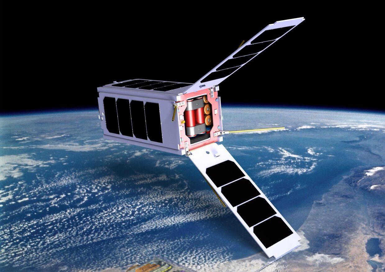
DARPA and US government agencies are exploring innovative space technologies and systems for dedicated military missions, as nanosats have become an attractive alternative to current expensive systems and architectures. Small satellites haven’t only lower development and launch costs, but provide further end-user capability options into civilian areas such as earth observation and humanitarian monitoring. Future nanosats and cubesats weigh under 5kg, cost around £300-500k and can even be launched from high altitude jets or balloons rather than traditional rocket launching.
Military demand for commercial satellite imagery is common place. The US Army seeks to exploit future nanosats for dedicated coverage for multiple users in remote areas. Many countries use this option, as it is possible to purchase satellite photos from commercial operators in colour, or black and white. Modern operational requirements indicate preferred resolution of 10-15cm but 40cm resolution available from civilian satellites is often accepted.
Nanosat high resolution cameras are thus equally relevant to earth observation. The military value of imagery depends on system resolution, whilst the tactical value of imagery depends on timelines. In other words, collection and processing of imagery in near-real time makes real-time targeting and situational awareness possible. Once again, processing capabilities are fundamental, making them equally relevant to humanitarian and earth observation applications, such as Coastguard requirements in cases of coastal flooding, piracy, etc.
The ability to provide persistency, defined as the ability to provide continuous maritime and littoral surveillance of any chosen area for the required period, is a high requirement for the downstream satellite user community. Typical comments include: “the persistent system would be required in the event of a piracy incident, enabling surveillance of movements of hostages” Night-Day capability, defined as “the ability to provide timely information for tactical operations at any time”, is also important to the upstream satellite manufacturing community, and downstream users: “because you want a safe coast you have to work night and day and in all weather conditions”, “and “our mission has to be done 24/7 partial coverage would not offer the operational capability requirement.”
Temporal requirements are important as seen from a recent frequency assessment of various end-users and are extremely varied. Some end-users require more than one answer. One South American response on this temporal issue stated. “An hourly frequency is enough to hail all ships inside the area of maritime operation.” Another UK response “Guaranteed daily, and then hourly when needed would be very useful for flooding applications.” There is no universal specific frequency requirement but frequency requirements are universal.
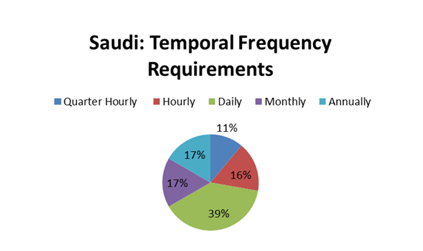 Figure 1: Saudi Arabian temporal frequency requirements
Current maritime resolution requirements
Current resolution requirements responses are varied, as seen in figure 2.
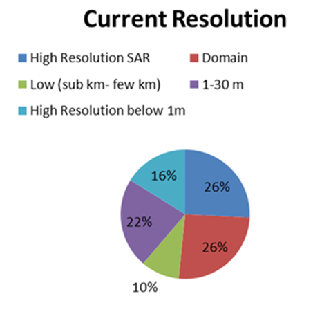 Figure 2: Various maritime end-users current resolution requirements
Nearly 1/4 of all responses from end-users only want domain awareness. For the general maritime picture, daily updates are sufficient (i.e. domain). Taken alongside figure 3 up to 10m and small fast boats approx. 20ft is the dominant category (43%). 1-3m resolution typically allows vessel recognition, whilst 300m+ is sufficient for tankers and full-sized ships. 10% of users state they require low (sub km-few km) resolution, nearly 1/4 want 1-30m medium resolution for target identification. 16% want high optical resolution below 1m, with 25% of respondents stating they require high resolution SAR.
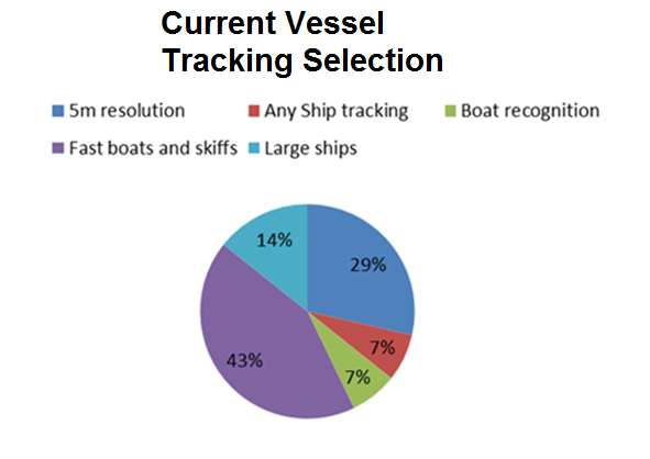 Figure 3: Current vessel tracking selection requirements
All weather capability is very important to maritime users. Where users were asked: “On a scale from 1 to 5 how important is X to your organisation’s operations, where 1 is Not at all important, to 5 Very Important?” The Qatar Coastguard provided 9 respondents which generated the returns indicated here, with all-weather capability regarded as dominant, i.e. Very important, and 8 out 9 responses lying within categories 4-5. The following typical response of all-weather capability importance is clear. “It will manage the coastal area and offshore area in bad weather when small boats (Coastguard) cannot go offshore.
The UK Government has invested some £1.2 billion in space since 2010, with 2015 a record year for start-up ventures. Having delivered a programme to the UK MOD, ESA awarded Roke Manor Research, a contract for SysNova, a nanosatellite technologies initiative, whilst Clyde Space secured a contract with Kepler for manufacture of two software defined radio communications nanosatellites.
The UK has highlighted the vital importance of the South West’s future Newquay spaceport for horizontal manned civilian launch, notably Virgin Orbit, to complement future Scottish vertical launch capacity. Even small countries like the UAE, with the NAYIF-1, and Lithuania with their 3kg LitSat-launched from the ISS in 2014, have entered this new space race. LitSat-1 was intended to test on-board systems and earth-satellite communications with a GPS receiver to detect signals in the Adriatic, but clearly such a mission was planned a long while in advance, and is thus not tactical in deployment.
Low cost nanosats have a 2-3 year design expectancy and reliability; they don’t require redundancy for long-life, nor do they need to survive harsh ‘space weather’ as they can be replaced as required. Nanosats have short, low-cost cycles, and provide persistence and resilience, now representing the most rapidly changing space sector. It is anticipated that there will be a new international nanosat space-race, driven by revolutionary and adaptable electronics technologies and new innovative launch providers.
Nano-satellites can however provide solutions for tactical applications requiring Night-Day operations, persistence, all weather-capabilities etc. SAR is certainly a solution for larger satellites. Many market-players stress the trend towards Smart Data Analytics, with hybrid optical-SAR tailored information for customers, improving SAR utility and earth observation data, potentially derived from a combination of small high resolution optical systems, and large high resolution SAR platforms.
This will support future commercialisation of the civilian space-based very high resolution SAR, most likely in consortia composed of multiple partners. One UAE respondent wanted “A satellite which can provide earth imaging, detecting piracy, and illegal ships,” and another response “During the winter, when the sea conditions reduce surveillance efficiency… and prevented smaller vessels from going to sea, RADARSAT would be useful.”
With more satellites in the 1-10kg category, and the price of high-resolution satellite imagery dropping, remotely gathered images are increasingly being used by the UN and other NGOs to investigate allegations of human rights and environmental abuse. Commercial availability of high resolution satellite imagery is a relatively recent phenomenon, only emerging since the start of the millennium, but already facilitates investigations of recent dramatic social events, including the destruction of homes in Sudan and Zimbabwe (figure 4) [1], and the environmental effects of the notorious Rio Tinto gold and copper mine in West Papua (figure 5) [2].
In Zimbabwe, May 2005, President Mugabe’s government began a campaign, Operation Restore Order, in which homes of 700,000 people were systematically demolished. Images were taken some time after the 6,190 residents of Porta Farm were driven from their homes. Gathering information in such places is often incredibly dangerous. Journalists have been killed trying to approach the Rio Tinto mine and aid workers may be targeted as they fly into remote areas in Sudan or elsewhere. Satellite imagery means we can find out what is happening in these areas without risking lives unnecessarily.
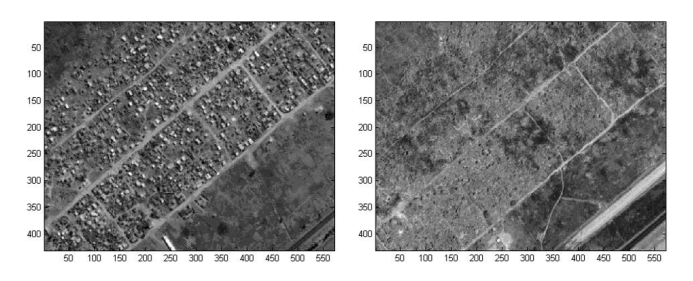
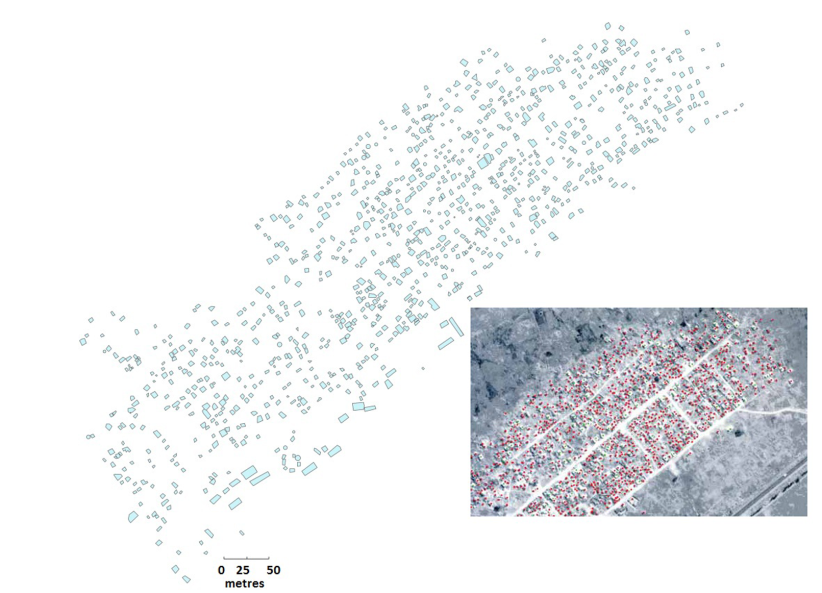
Figure 4: Zimbabwe Land Clearance
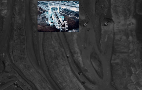 Figure 5: Imagery distinguishes crawler machinery from ore trucks
One ongoing problem is the reporting of accurate locations which are often confused in reports. However, once a place has been located, analysts usually aim to acquire a set of before and after images, which they compare for evidence of wrong doing. However, in a response to urgent humanitarian abuse claims in remote and obscure areas this isn’t always possible, and takes no account of the skies being cloudy above.
Military systems provide interesting possibilities here. Requirements for highly detailed satellite imagery globally, available 24/7/365 has driven satellite data providers to reassess the ways in which they conduct their business. Although optical sensors provide satellite imagery today with typically 40cm resolution, they are limited to daylight hours, and may be further restricted by poor weather, smoke, and in the case of the military, battlefield obscurants. The preferred military solution is imaging radar, which can operate under darkness and in challenging battlefield or environmental conditions.
The commercial market potential is also significant, with governmental, and NGO users, looking to obtain detailed large-area views rapidly. Currently there are some 30 proposed satellite radar sensors planned for launch. Imaging radar, or Synthetic Aperture Radar creates images of ships vehicles, and aircraft, and often mounted on moving platforms such as aircraft or satellites.
Current commercial drivers look to provide increasing improvements in decreased resolution and component size, with demands for foliage penetration, improved strip, scan and spotlight modes, and rapid data products from imagery acquisition to delivery. Existing large SAR system manufacturers have a head-start in experience over small start-up companies, but significant cost reduction will require a shift in operational mind-set. Small start-up companies like Capella in the USA, already building on a foundation of defence engineers, must out complete current big-market players such as Airbus.
High resolution terrain surveillance is already common place. If a vehicle convoy drives over a dirt track at night the ground becomes compacted by several millimetres, so the vehicles’ paths are easily seen with SAR, and can detect changes due to water, mineral, oil or gas extraction. China has entered the strategic SAR market with Gaofen 3, a 3-tonne C-band SAR satellite officially for natural disaster monitoring, and part of the Chinese High-resolution Electro Optical system (CHEOS) network providing near real-time data to government agencies with 12 imaging modes and 1m resolution. But current massive SAR-based systems have a long way to go before becoming small, easily deployed tactical systems! However, this may not be so far off as SAR is a strong growth market-area, particularly for maritime persistent stare and satellite imaging.
Although the information gathered often needs to be ‘ground-truthed’- combined with eyewitness reports- the resulting evidence is still strong. Even low-resolution imagery on sites such as Google Earth can have a powerful effect. Researchers at Survival International who worked on a campaign against construction of Vedanta’s aluminium mine in The Niyamgiri Hills in Eastern India sacred to the local tribal people, the Dongria Kondh. The company claimed it had taken Dongri Leaders to the nearby Panchpatmali mine so they would see the positive impact of bauxite mining. However, Survival International, showed shareholders satellite images of the destruction caused by the existing mine (figure 6) which helped persuade high-profile shareholders to consider selling their shares.
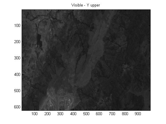 Figure 6: Panchpatmali Mine, Orissa 2002 Panchpatmali Mine, Orissa 2009
As high-resolution satellite imagery becomes cheaper and more accessible, human rights activists and environmental organisations are increasingly using it to uncover and investigate instances of abuse from around the globe in a timely manner. The next generation of military tactical nanosatellites offers the possibility of providing such ‘perishable’ information for civilian and UN earth observation activities. Many examples such as Darfur in the Sudan, my own case studies, and others are available. Today there are few corners of the globe beyond the long reaching capability arms of satellites, whether electro-optical or radar. But information is still required, and must be acted on in a timely fashion, otherwise it remains just highly ‘perishable’ information.
[1] LAVERS., C.R., and T.R. MASON, High-resolution IKONOS satellite imagery for normalized difference vegetative index-related assessment applied to land clearance studies. Journal of Applied Remote Sensing 11(3), 035008 (4 August 2017) doi:10.1117/1.JRS.11.035008.
[2] LAVERS, C.R., MAZOWER, J., GRIG, S., (2010) RSPSOC ANNUAL CONFERENCE Proceedings “Application of high-resolution satellite imagery to environmental assessment of mining impact in West Papua”.
“Written and researched by Dr Chris Lavers Principal Scientist, Satellite and Electro-Optical Maritime Sensing Applications, Sea Power Centre, Britannia Royal Naval College, Dartmouth, and Subject Matter Expert (Radar and Telecommunications), Plymouth University at BRNC.”