Today, environmental stresses on resources are not the only factors involved in natural, or man-made, societal destabilisation. Societal infrastructure composes many important and often inter-related categories: water, food, health services, emergency services, environmental protection, and electricity, etc., where large-scale disruption could be devastating especially to complex urban mega-cities.
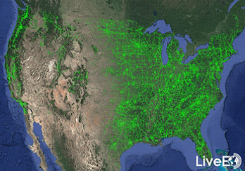
However, to military and civilian crisis management today, the accelerando of new technologies availability, in this fourth industrial revolution, provides many sophisticated tools to monitor sensitive ‘life’ support systems. One of particular image surveillant value is medium to high resolution satellite imagery. Satellite imagery can now help establish the risks to national infrastructure from natural and terrorist hazards. The 2018 Berlin-based start-up LiveEO (figure 1) recently demonstrated for the first time, provision of satellite-based vegetation risk analysis for the entire United States electricity transmission grid. Results reveal exciting insights about vegetation conditions along over half a million miles (574,000 miles) of overhead lines. LiveEO used nearly 15,000 individual satellite images to evaluate risk. A detailed analysis of their work is to be found at www.live-eo.com/us-power-transmission-grid-analysis .
Further analysis will inform management processes to help decrease wildfire, as well as potential storm damage risk. Analysis so far has identified grid segments which are exposed at dangerously close distances. Vegetation is one of the main challenges for the majority of utilities, causing up to 56% of externally triggered electrical power interruptions. Applying such mapping to other critical national and global infrastructure, gas, water, etc., will be a key activity for civilian, military and disaster operations for both power sustainment, as well as power restoration in the event of power outages.
“The scale combined with the detail of the analysis represents a milestone in satellite data analytics for utility companies and proves that satellite data represents a viable alternative for vegetation management to Lidar or foot patrols.” says LiveEO’s Co-Founder Daniel Seidel. LiveEO now has 40 employees with exceptional expertise in their respective fields. You can find out more at www.live-eo.com.
Besides the sole detection of vegetation distance from transmission grids, LiveEO is experienced in the investigation of highly accurate and efficient investigations of vegetation height, condition, and species determination to improve cycle trimming activities and dangerous tree removal while reducing vegetation management costs on transmission and distribution levels. The potential for monitoring forestry has potential wide-scale global implications for conflict-related deforestation. The LiveEO methodology could be useful across South American, South East Asian and African hardwood forests. For example Sudan is home to some of the oldest African teak plantations, with illicit hardwood trade now important in regions plagued by trans-national wars. Sudan’s Central Equatoria teak economy, is now estimated to generate some US$50-70M dollars per annum in forest-related revenues. Illegal harvesting currently takes place with local and defacto authorities, just as traders defer to Al Shabaab throughout Somalia rather than to official authorities. Satellite imagery can provide an independent evaluation of the overall state of the logging industry, and is well-suited to remote global hardwood monitoring.
Additionally, LiveEO is currently helping utility companies to identify wildfire risk areas and inspect post-wildfire areas with high precision for fast recovery activities. Furthermore, “these insights can be made actionable directly via our tool set of mobile and web apps, and Application Programming Interface (API) integrations to improve workforce efficiency in the field and to realise operating expenses savings,” relates LiveEO’s Co-Founder Sven Przywarra.
With multiple utility and infrastructure customers in North America, Europe, and Australia, LiveEO has proven its capabilities in numerous pilot projects with large-scale deployments on the scale of entire countries. To strengthen contact with its customers by physical presence, LiveEO opened an office and subsidiary on the East Coast of the U.S. in late 2020 and they offer a sample analysis using commercial satellite data of their network free of charge for utility customers.
LiveEO offers the world-leading satellite-based monitoring solution for infrastructure operators in the utility industry for vegetation management, and ground deformation. LiveEO’s products now help customers in more than ten countries, among them: Australia, the United States, and various European countries, to monitor their assets and decrease operational expenses.
There is now doubt that in the presence of increasing population, resource scarcity, climate-change pressures, ethnic rivalries, and religious conflict, the importance of time/location stamped high resolution satellite imagery will become more important than ever to assess global risks to human actors, critical infrastructure, and the environment.