_________________________________________________________________________________
When and where are boundary rips active?
Boundary rips can be found on beaches with headlands, rock outcrops or coastal structures. They are typically created when longshore (littoral) surf zone currents are deflected seawards. Headland boundary rips can become severe in large waves and typically reach farther offshore (up to 3–4 surf-zone widths) than beach rips on similar beaches. High-energy boundary controlled rips are often called ‘mega rips’.
Boundary rips can form on low-energy beaches that only occasionally receive high waves. These beaches are very common throughout the UK and northern Europe, where coastal structures and rocky outcrops often extend from the beach straight out to sea (shore-normal). They are a significant cause of boundary rip hazard, particularly on more sheltered beaches that have no beach rips and are not exposed to open ocean swell waves.
These beaches are commonly located on what are called ‘drift-aligned’ coasts, where waves mostly arrive to the beach at an angle, creating longshore (littoral) currents that result in the movement of sand along the coast. In northern Europe these beaches are often found within smaller sea and channel environments (e.g. North Sea and the English Channel) that have a short-fetch and are dominated by locally generated wind waves.
These beaches can experience rapid changes in the longshore (littoral) current direction due to changes in wave height and wave angle driven by local winds. The intermittent nature of these reversals can catch beach users unaware.
Are boundary rips a major bathing hazard?
- In the UK, research suggests that boundary rip currents are potentially implicated in at least 13 accidental coastal drownings per year.
- Boundary rip currents are a key cause of incident on RNLI beaches (24 lives saved per year from 2006 to 2011).
- 21% of all rip incidents between 2006-2011 were involving boundary rips (2629 incidents).
- Lives saved associated with boundary rips (geology and man-made structures) made up 26% of all rip related lives saved recorded (143 between 2006-2011).
- If we extrapolate these statistics to non-patrolled beaches it is clear that rips associated with physical obstructions are likely to be a major factor in coastal drowning.
An assessment of all UK bathing beaches by Plymouth University and the RNLI indicated that 74% were classified as being modified by coastal structures, 33% of which have groynes and 21% have breakwaters. In addition to this, 62% have natural geological outcrops and 56% have headlands leading to plenty of topographic rip potential.
What is controlling boundary rip hazards?
To improve our understanding of boundary rips and the threat they pose to bathers, particularly on coasts with smaller waves, Plymouth University and the RNLI conducted research in Poole Bay to gain new scientific understanding about how boundary rip currents behave around solid structures in the surf. This involved the measurement and computer modelling of boundary rip currents around a groyne system during a range of wave conditions.
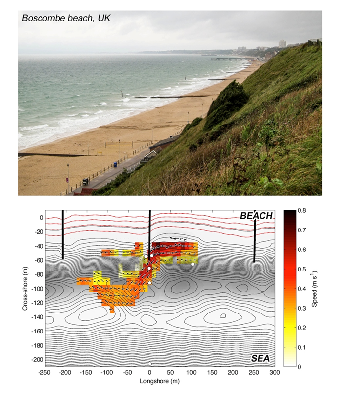
Bottom: the results from the release of GPS-tracked drifters into a boundary rip over a period of 2 hours. The arrows and colours show average rip flow direction and speed.
This research suggested that, like channel rip currents common to open beaches, the physical characteristics of boundary rip currents can vary in a number of ways that affect bathing hazard. Of particular importance were:
- Rip strength.
- Rip circulation (offshore extent of rip current and rip exits).
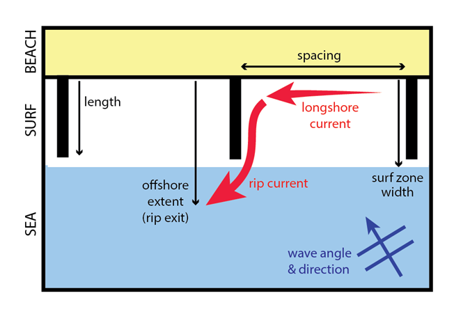
The flow strength and offshore extent of the rip flow vary due to a number of environmental and structural factors that change rip current behaviour:
- Waves – The characteristics of the waves (height and direction) control the rip flow speed.
- Obstruction dimensions – The spacing and length of the obstruction control the rip flow speed and the offshore extent of the rip flow.
Flow Strength
The strongest rip flows normally occur on the upstream side of the obstruction where the longshore current, generated within the embayment, is deflected offshore. The research team measured rip speeds of up to 1 m/s under relatively small wave heights (average wave height < 1 m), with pulsing rip speeds reaching 2 m/s. These are very strong currents that would present a significant hazard to an inexperienced bather.
Measured rip speeds for a given wave height were stronger for topographic rips than beach rips, but the flows are more confined and occur in a fixed position. GPS-drifter observations at Boscombe indicated that topographic rip flows could reach up to two surf zone widths (~120 m) from the beach, again much further than for beach rips.
Wave height and angle
Research findings clearly indicated that rip flow speed was strongly correlated with the predicted longshore current speed, a combination of the wave height and wave angle. The wave angle is of particular importance in the creation of boundary rips.
The effect of wave angle on rip speed was found to be greater under higher waves. In fact, rip speeds were found to be very low for waves of any angle below a wave height of 0.5 m. For waves above 0.5 m rip speed was much more sensitive to wave angle; a rapid increase in rip speed occurred when there was a significantly large wave angle (~45˚).
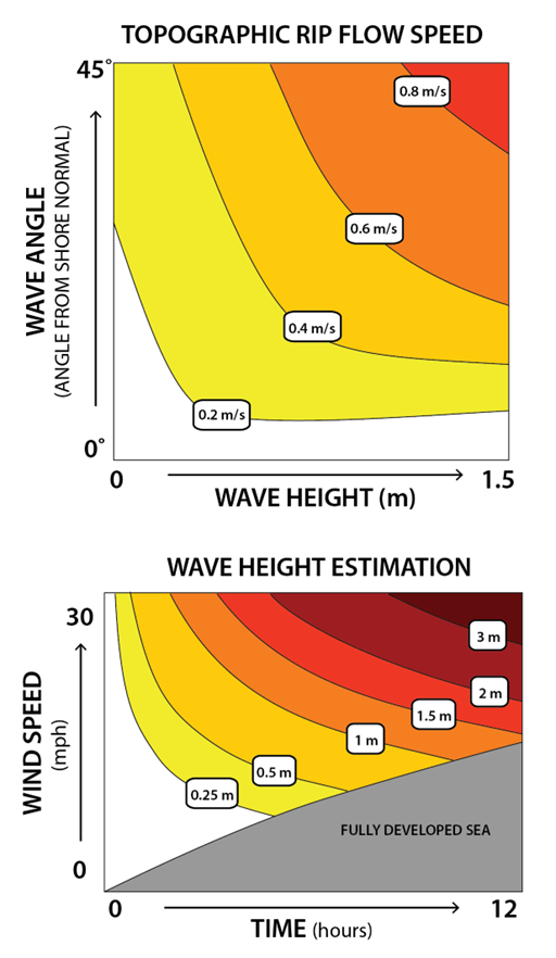
Bottom: how ‘rule-of-thumb’ maximum wave heights can be predicted from the wind speed and duration. This method is useful for the prediction of rip hazard if wave forecasts are unavailable or unreliable.
Obstruction Dimensions
Obstruction spacing: Rip flow strength
Rip spacing can have a significant control on rip speed. As waves approach a beach at an angle, a longshore current is generated. Coastal structures like groynes are designed to modify this current to protect the beach. If there is more than one obstruction in the surf, the upstream obstruction will block a significant amount of the longshore current flow. Therefore, the spacing to the next obstruction will determine the distance over which the longshore current can redevelop. This in turn controls the strength of the deflected rip current at the downstream obstruction.
Research showed that when obstruction spacing was greater than four times the obstruction length the increase in rip flow was small. But, the reduction of rip spacing from four to two times the groyne length significantly reduced rip speed by up to 25%.
For short groynes (or groynes with greater permeability) where the obstruction to the longshore current is less, the effect of groyne spacing will also be less. Therefore, groyne spacing becomes an increasingly important with increasing groyne length.
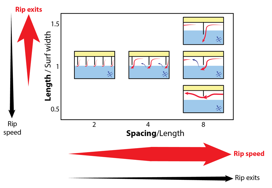
Obstruction length: Rip exits
Through the use of computer models, researchers from Plymouth University have been able to analyse rip flow patterns around obstructions of varying lengths, in combination with measured rip patterns (GPS-drifters).
The findings showed that groyne length in relation to the width of the surf zone controlled the distance that the rip flow would take a floating person offshore and the amount of surf zone exits (likelihood that a bather in the rip would go out beyond the breaking waves).
The ratio of obstruction length from the shoreline and the surf zone width determined the rip flow deflection.
1) An obstruction much shorter than the surf zone formed a meandering longshore current within the surf zone where surf zone exits are low.
2) An obstruction much longer than the surf zone formed an offshore flowing jet where the longshore flow was completely deflected offshore and rip exits were very high.
3) An obstruction around the same width as the surf zone represented a transition between the two behaviours.
Hazard
Boundary rip current risk levels are a balance between rip flow speed, circulation and bather exposure. Boundary rips occur on high- and low-energy beaches but they can present a particularly high risk of harm to bathers on beaches that are predominantly low-energy. These beaches do not usually have beach rips and the boundary rip hazard is often intermittent. This can lead to an absence of lifeguard cover, lower rip experience amongst beach users and an element of surprise when rip flows are strong.
Understanding the rip flow speed is critical for hazard assessment. The rip speed look-up chart provides a predicted rip flow speed as a function of the offshore wave height and wave direction. If the availability or reliability of wave information is poor a ‘rule-of-thumb’ method using established equations to estimate the potential maximum wave height based of wind speed and duration.
If assessing multiple obstructions, spacing should be considered a modifying factor in the estimation of rip flow speed. If spacing is less than four times the groyne length, maximum rip flow speeds are likely to be significantly less than predicted.
The offshore extent of the rip (likelihood of the rip flow exiting the surf zone) is also important in the assessment of rip bathing hazard.
- Long-term: If the obstruction length is greater than the typical surf zone width under med/high energy conditions, rip exits beyond the surf zone will dominate, presenting a greater hazard. Flows can reach up to two surf zone widths offshore. If the obstruction is less than the typical surf zone width then rip flows increasingly remain within the surf zone presenting a lower hazard.
- Short-term: The variability of wave height will affect the surf zone width. A reduction in surf zone width with smaller wave heights will increase the effective obstruction length increasing the offshore extent of the rip current. Therefore, there may be cases where rip flows are more hazardous to bathers under medium rather than high-energy conditions.
Additional considerations
In addition to the obstruction of flows, considerations must be made of a range of modifying site-specific factors:
- The local bathymetry can modify the waves before they break. For example, a shallow offshore seabed slope can increase wave refraction leading to a reduction in wave angle (from shore normal) at breaking, and vice versa for a steeper slope.
- The movement of the tide will sometimes have a significant effect on topographic rip behaviour. Key rip parameters like the obstruction length, surf zone width, wave height and wave angle can all be affected by the tidal level. For example, in some UK locations, particularly when groynes are designed to protect a steep upper beach which is fronted by a wide low-tide terrace, it is common for the low tide shoreline to drop past the groyne tip altogether, leaving the structure dry periodically.
- Daily tidal movement can create tidal currents that often flow along the coast. In some cases these currents can have a significant influence within the nearshore zone, creating an oscillating (~6hr) longshore current that, although typically weak, may modify wave-driven longshore currents.
- Beach morphology. Finally, it is important to consider the impact the obstruction has on beach morphology. By modifying the waves and currents, in turn the beach morphology will be affected just like any other dynamic beach system. The impact of groynes on intermediate beach types (e.g. Low-tide terrace) can be important in the development and fixing of permanent beach rips both adjacent and seaward of the obstruction. These rips may be more similar to beach rips. At the other end of the scale, in a case where obstructions occur on a steep reflective beach, the rip flow will be controlled directly by the obstruction.